251AWeb Development 10AnnieW101233@wpga.ca-MCBF2

Winter Digital Marketing Campaign
Annie Wagner
Note: This project is not the Mailchimp Winter Sales one but one of 4 new projects. I have handed in the Winter Sales one previously:251AWeb Development 10AnnieW101233@wpga.ca-MCBF

Winter Digital Marketing Campaign
Annie Wagner
251AWeb Development 10AnnieW101233@wpga.ca-NHL

NHL Data Science Project
Annie Wagner
Annie Wagner’s Portfolio

Remembrance Day Poppies

I made these poppies for Remembrance Day using Adobe Illustrator.
Tech News Story One: Social Media Banned for All Children Under 16 in Australia

In November, Australia passed a bill banning social media for all children under the age of 16. This ban is the most restrictive one currently in place in the world, and has the highest age limit. Many Australians believe that this is a step in the right direction, but others are worried about negative impacts on youth.
The main reasoning behind the ban is to free youth from the confines of harmful content and addictive apps. “We want our kids to have a childhood and parents to know we have their backs,” Anthony Albanese, Prime Minister of Australia, said (credit BBC). It’s hard to disagree with this sentiment; we all want children and teens to enjoy their lives and be safe online, and the social media ban will help protect young people from the dangers of this kind of technology. However, experts are worried that the ban could prevent teens from connecting with their friends online, leaving them feeling isolated. Additionally, there are concerns about privacy with possible age-verification technology, which could involve biometric recognition of the faces of children and adults alike.
How the ban is implemented and its positive or negative effects remain to be seen. Depending on the outcome, other countries, like Canada, could follow suit, or if the ban is ineffective, go down alternative paths for protecting children on social media.
Personally, I think that the ban has both positive and negative attributes. As a teenager, I am aware of my and my friends’ social media usage, and the positive and negative impacts it can have on our mental health. I take steps to avoid overusing social media, but not every teenager does, and this can lead to a lack of sleep and poor performance in school and other activities. While a flat-out ban may not be the ultimate solution to the social media problem, it will force tech companies to make their platforms safer for kids or risk losing a significant portion of their users. I look forward to seeing the positive impacts that will most surely come from this.
Sources:
https://www.bbc.com/news/articles/c89vjj0lxx9o
https://www.cbc.ca/news/world/australia-social-media-ban-1.7395487
https://www.theguardian.com/media/2025/feb/22/social-media-bans-for-teens-australia-has-passed-one-should-other-countries-follow-suit
https://www.google.com/url?sa=i&url=https%3A%2F%2Fwww.usatoday.com%2Fstory%2Ftech%2Fnews%2F2024%2F11%2F28%2Faustralia-social-media-ban-for-minors%2F76643584007%2F&psig=AOvVaw1I8aUzdO6R1ccuWPPcenAo&ust=1741709745789000&source=images&cd=vfe&opi=89978449&ved=0CBcQjhxqFwoTCMCUzcn0_4sDFQAAAAAdAAAAABAE
Project 1: Life Sciences Practice Test- Google Form

I created this Google Form to act as a practice test for an upcoming Life Sciences 11 exam. It involves questions from all units and gives users a score out of 14 once they have completed the test.
Tech News Story Two: Smart Ray-Bans

In October of 2023, Meta Ray-Bans were released, which put photo, video and AI capabilities into a pair of fashionable glasses. These glasses allow wearers to listen to music, take photos and videos, livestream from the glasses, send messages, and ask AI questions, all without even taking out their phone. The glasses are reported to be as comfortable as regular ones, only weighing “a couple grams more” than their non-AI counterparts. With a long battery life and stylish, comfortable frames, these smart glasses could be the wave of the future. However, there are also some concerns with the ethics of the technology. Two Harvard students proved that while AI glasses are cool, they also raise some concerns about privacy.
Combining facial recognition programs with AI assistants, the students approached strangers in the subway station and tested the technology on them. Once in about every 3 people, the glasses recognized a face and pulled information from the internet about them, including information about their job and possibly even where they live. They then introduced themselves to the strangers, asking them questions based on the information retrieved about their identities. The strangers, a bit confused to be greeted by someone they’d never met before, had no idea what was going on until they saw the video of the encounter posted later on social media.
Personally, I believe that the Meta Ray-Bans are a great new invention that will be helpful to many people, but we also must be careful about respecting people’s privacy, especially when such useful technology is right at our fingertips. The same expectation of courtesy and etiquette with phones should be upheld with smart glasses and any other kinds of wearable electronics. In the end, always stop and think before you record someone or use facial recognition mechanisms, and ask yourself if it is the right thing to do. When in doubt, just ask for permission.
https://www.nytimes.com/2024/10/24/technology/facial-recognition-glasses-privacy-harvard.html
https://www.cnbc.com/2023/12/09/ray-ban-meta-smart-glasses-review.html
https://www.google.com/url?sa=i&url=https%3A%2F%2Fdowntown-mag.com%2Fen%2Fray-ben-meta-smart-glasses-review%2F&psig=AOvVaw3dTrSoUw-BTc9bmT2XYjI5&ust=1741897468809000&source=images&cd=vfe&opi=89978449&ved=0CBcQjhxqFwoTCIi34_OvhYwDFQAAAAAdAAAAABAE
Project 2: Adobe Illustrator Parrot

I used Adobe Illustrator and watched a video on how to make a parrot using Illustrator functions such as the ellipse tool, layering shapes and then subtracting parts to make half-circles, and using the eyedropper tool to make everything the same colour.
Tech News Story Three: Synthetic Media

The rise of artificial intelligence in many aspects of communication and information sharing, such as social media posts, has also given rise to what is known as “synthetic media”. Synthetic media refers to any photo or video that has been altered or changed in some way to make it different. AI allows us to create all sorts of synthetic media, from photos of ourselves with cat filters to reels on social media to AI-generated trip itineraries. This kind of technology has led to advances in the film industry and other creative industries, improving some already-existing features such as CGI and making cinema even better. On a smaller scale, we can create fun social media posts that we share with our friends which were made through the assistance of AI. While all of these aspects of synthetic media are beneficial, AI has recently been used in the spread of disinformation.
Deepfakes, or fake videos of famous people, have become more and more common in our world, and harder to spot. Videos of politicians and celebrities, usually saying or doing outrageous things, proliferate across news and social media platforms, often spreading fast and far before fact-checkers can debunk them. This can lead to consumers being easily manipulated by fake videos, and believing the ideas and opinions that they share, which are most often harmful. In today’s uncertain political landscape, this type of synthetic media could wrongfully damage the reputations of different parties or candidates, causing their supporters to lose faith in their platforms or even support a different party, all because of false information.
I believe that synthetic media has both positive and negative impacts on society. The positive aspects should be enhanced and celebrated, and we should reduce the negative aspects through consumer education, legislation and forms of technology that can combat deepfakes. We should also enjoy the benefits we reap from AI, but be conscious of the ways it can be used for harm, making sure to never spread misinformation and always protect ourselves from the influence of this technology.
https://innovating.news/article/synthetic-media-deepfakes
https://www.synthesia.io/post/the-future-of-synthetic-media
https://threatpost.com/black-hat-2020-open-source-ai-to-spur-wave-of-synthetic-media-attacks/158066/
Project 3: Photoshop “Wacky World”

I used Photoshop to create this wacky scene. I took pictures off of the internet and combined them to form new animals, using the selection, blur, remove background and erase tools. I generated the background using AI.
Tech News Story Four: 23andMe Bankruptcy

The popular genetic testing company 23andMe has recently filed for bankruptcy, leaving many people wondering what will happen to the data the company has collected. Much of the information gathered from genetic testing can be quite personal. From your ancestry to your susceptibility to certain diseases to many other characteristics, companies like 23andMe provide users with lots of information. DNA testing is comprehensive as it looks at the whole genome, and can allow people to better understand themselves and make informed decisions about their health and take preventative measures to help ensure a better future.
Unfortunately, as 23andMe has filed for bankruptcy, all of this valuable, yet sensitive, information could be changing hands very soon. Another company could buy 23andMe, and that company could have different privacy laws that don’t adequately protect the data of their customers. A data breach already occurred in 2023, exposing many customers’ data without their consent. Attorney general of California Rob Bonta said “Given 23andMe’s reported financial distress, I remind Californians to consider invoking their rights and directing 23andMe to delete their data and destroy any samples of genetic material held by the company,” (The Toronto Star), echoing the comments of other experts.
I believe that, in a world where many aspects of our life and information about us is stored online, we have to be careful about who we share our personal data with, and whether the risk is worth it at all. Once your information is out there, it’s often hard to retrieve it. When using online genetic testing, it’s important to take all possible steps to protect yourself. Putting personal information in the hands of someone else is always risky, so be prepared for all possible outcomes, including data breaches, before using such services.
Sources:
https://www.cnbc.com/2025/03/25/how-to-delete-23andme-genetic-data.html
https://www.nytimes.com/wirecutter/reviews/23andme-data-bankrupt/
https://www.23andme.com/en-ca/membership/
Project 4: Mailchimp Campaign: Best Off-Campus Lunch Spots


I created a Mailchimp campaign, with an attached Google Form, surveying people about the best places to each lunch off-campus. The first image is a screenshot of the email, and the second one is the embed code for that email.
Tech News Story 5: Digital Twins: How the Fashion Industry Is Moving Towards AI Models

Famous fashion company H&M recently announced that they are going to start using AI models for marketing purposes. This campaign is an exciting opportunity to try out new forms of technology in a never-before-seen way. Many models are excited about this idea. It will allow them to be in “multiple places at once” (through their digital rendering). Without sacrificing pay, they will be able to take on more contracts and further their career by modeling for companies that may be far away from where they live. Spokespeople say that the models and their agents will have full control over their digital twin, just as if it was a real picture of themselves. This project could cut down on costs for the company and reduce travel time for the models.
However, there are also concerns about this kind of technology being used against the wishes of the models. Clothing institutions could potentially use a digital twin in advertising without properly compensating the model for it, or apply the likeness in ways that the model doesn’t consent to. Additionally, professions associated with photo shoots, such as photography, makeup art, hair styling, and equipment setup could find themselves out of a job. To cut costs, money has to be saved somewhere, and in this case it would be by getting rid of all the jobs associated with organizing and running a photo shoot.
In a constantly developing tech and fashion industry, policies and regulations can often fall behind innovations. The AI fashion industry could make the lives of models and companies much easier, extending the reach of their products. Sadly, it could also render many jobs void, and leave people out of work, or provide an opportunity for future companies to misuse digital likenesses in whole new ways. I believe that this kind of technology should be closely monitored and followed by laws to protect workers from the negative aspects of AI models, but not prevent industries from experimenting and progressing. We all have to make sure that as our world is developing no one is being harmed in the process.
Sources:
https://www.bbc.com/news/articles/c3vwg73xndeo
https://www.businessoffashion.com/articles/technology/hm-plans-to-use-ai-models/ https://www.google.com/url?sa=i&url=https%3A%2F%2Fwww.just-style.com%2Fnews%2Fsignal-hm-explores-ai-potential-as-global-safety-summit-highlights-risks%2F&psig=AOvVaw2h_AgIuZGAWLnyxz1lt_lM&ust=1743201277471000&source=images&cd=vfe&opi=89978449&ved=0CBcQjhxqGAoTCJiNofmoq4wDFQAAAAAdAAAAABCAAQ
Tech News Story 6: Bird Lasers: How Technology Is Being Used to Combat the Spread of Avian Flu

Avian influenza (H5N1) has been a problem for a long time, but the effects of the virus have grown in recent months and years. Wiping out millions of birds from a flock and decimating farms, H5N1 has made its mark. Unfortunately, that’s not the end of the story. Avian flu has spread to dairy farms, infecting cows and even human workers. While avian flu can’t spread from person to person yet, if the virus keeps spreading and mutating, it could happen soon. With a crisis looming in the future, experts were looking for a solution to the problem. They found one: lasers.
Originally used around airports to stop birds from landing on the runway, lasers provide an eco-friendly and harmless solution to the problem of keeping wild birds away from farms. Invisible to us and safe for animals and people, the technology is an excellent way to stop the spread. When installed on the top of a building, they form criss-crossing lines that birds perceive as objects, so they do not land. Farmers in Minnesota have tested the use of the lasers on farms, and they appear to work perfectly. A couple of months ago, the Minnesota government even gave out grants to farms to help subsidize the cost of installing these lasers.
With avian influenza cases rapidly increasing, I think that technology, whether it is bird deterrents or vaccines, is the only way we will solve the problem and prevent it from getting worse. Technology has been used to solve all kinds of problems, and this issue is no different. Also, this design is not new: lasers were already in place in airports. Sometimes, the answer isn’t hard to find: You just have to look around at the tools you already have, and one of them might just work.
https://www.cbsnews.com/minnesota/news/minnesota-farm-bird-flu-laser
https://m.farms.com/news/high-tech-help-may-be-on-the-way-to-keep-avian-flu-at-bay-224288.aspx https://www.google.com/url?sa=i&url=https%3A%2F%2Fbirdcontrolgroup.com%2Flasers-prevent-the-spreading-of-the-avian-influenza-virus%2F&psig=AOvVaw0sm0D6eFGpiZmw0bXRFXbd&ust=1743369326175000&source=images&cd=vfe&opi=89978449&ved=0CBcQjhxqFwoTCNi7uP6asIwDFQAAAAAdAAAAABAE
My OBS Overview
Here is an OBS overview of my portfolio and website.
Annie’s Test Post

Annie Wagner’s Portfolio
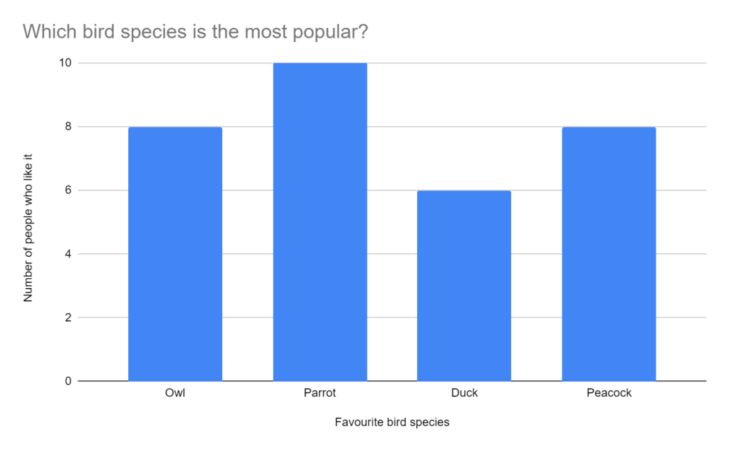
Which bird species is the most popular?
Here is a chart demonstrating which bird species is the most popular:
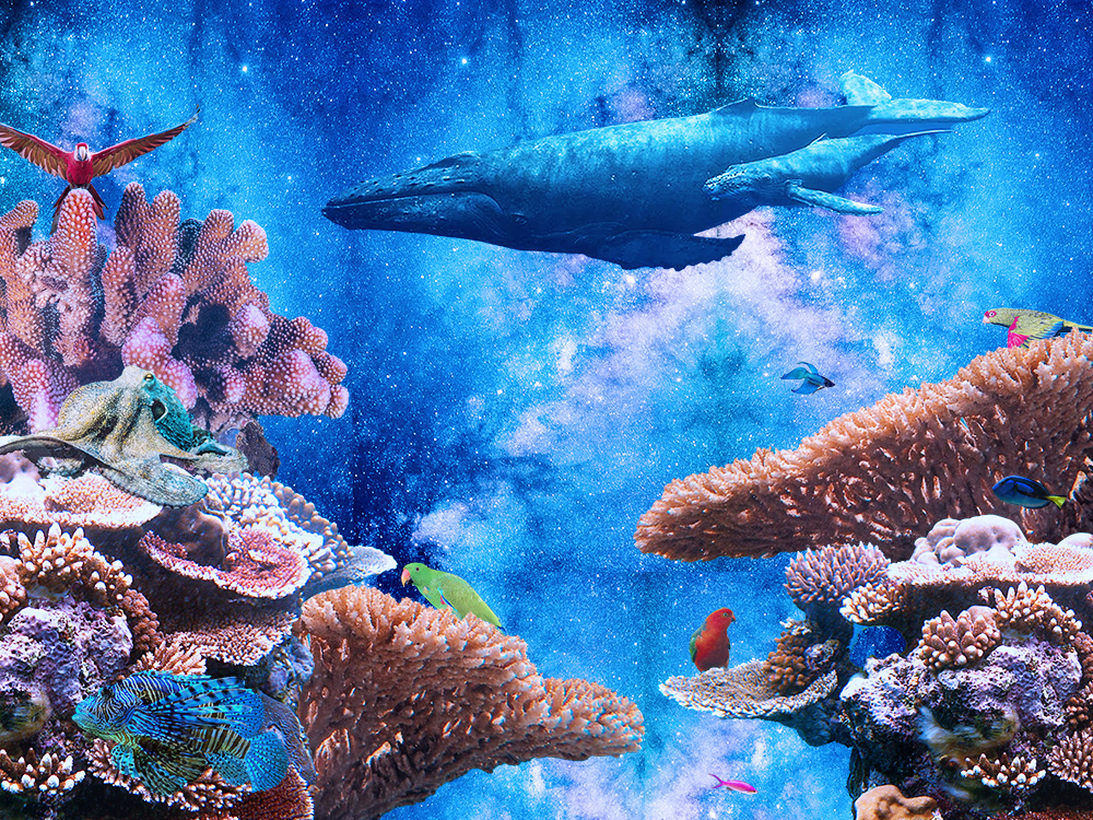
<iframe width="745" height="461" seamless frameborder="0" scrolling="no" src="https://docs.google.com/spreadsheets/d/e/2PACX-1vQnyLIrMc-Miy5pIxAkPFcwMYiCumZ9DzqMv39vDdAAfmgeG56dD4Qv1mNehEc07r8I4ki8Ym7BeAwC/pubchart?oid=979151072&format=interactive"></iframe>Photoshop: A Starry Sea
Tech News Story One: How Whale Safe Protects our Finned Friends
On May 8th, 2024, a New York harbour was greeted with a sad sight: the body of a sei whale stuck to the front of the cruise ship MSC Meraviglia.
While shocking and grisly, this sight isn’t uncommon. Each year, around 20,000 whales die after being hit by boats.
Sometimes, the deaths aren’t from a lack of effort on the company’s part. In a quote from CBC, an ambassador for MSC Cruises says “we are deeply saddened by any loss of marine life,”, and explains how the company attempts to avoid hitting whales by slowing down in certain areas of the ocean. Unfortunately, this wasn’t enough to prevent the death of the whale.
One thing that’s certain is that the death is a major black eye for MSC Cruises. Consumers care now more than ever about the environment and sustainability, and this incident is exactly the kind of thing that turns people off. Whether it’s truly the company’s fault or not, their reputation will be marred, at least for the moment.
Luckily, it doesn’t have to be this way. In 2020, a digital map known as Whale Safe was released, hoping to slow the rise of whales being hit by boats. Developed in Santa Barbara and currently operational in California, Whale Safe provides an interesting solution to a growing problem.
The digital map works by compiling acoustic and visual data about where whales are situated on a day-to-day basis, as well as information about weather and water conditions, and distributing it to boats in the area. First, whale calls are detected by using microphones known as hydrophones. When a call is detected, we know that there are whales present. Next, whale sightings from tourist boats and aerial photographs provide exact information on where whales are and sometimes their species as well. Finally, Whale Safe looks at ocean conditions and determines where whales are most and least likely to be on a given day. With all of this information combined, Whale Safe provides a comprehensive picture of the marine life present in major shipping routes off the coast of California.
The last step in the the process that Whale Safe goes through is information distribution. Information about whale locations is made available to all commercial boats.
In areas where whales are prevalent, boats are advised to slow down to a speed of 10 knots, decreasing the chance of a fatal strike. Research has shown that just decreasing speed is enough to significantly reduce the risk of death for nearby whales.
However, not all companies choose to slow down. Because of this, Whale Safe assigns all shipping companies a letter grade, ranging from F to A+. These ratings are visible to consumers and shed light on companies that are not doing their part to avoid hitting whales. A bad grade can hurt a company’s reputation and decrease customer satisfaction, forcing them to adopt the safety policies.
Due to the revolutionary technology created by Whale Safe, our finned friends will be much safer in their home waters. Hopefully, in the near future, Whale Safe will expand its map to include shipping routes across the world. Whale Safe is one step towards a happier and healthier ocean, which benefits us all.
Sources:
https://www.cbc.ca/news/world/cruise-ship-dead-whale-1.7198019
https://www.cbc.ca/news/canada/new-brunswick/whalesafe-marine-vessel-map-1.7172158
https://baleinesendirect.org/en/five-promising-initiatives-to-prevent-collisions-with-whales
https://whalesafe.com/about-us/
https://nautil.us/why-ships-kill-thousands-of-whales-every-year-381538/#:~:text=Yet%20an%20estimated%2020%2C000%20whales,even%20realize%20that%20it’s%20happening.
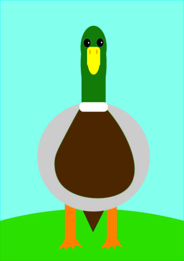
Adobe Illustrator Mallard
Tech News Story 2: How ShakeAlert Will Keep Us Safe When the “Big One” Comes

A massive fault line, known as the Cascadia Subduction Zone, stretches from British Columbia to parts of California, encompassing large areas of the western coast of North America. Every couple of hundred years, a massive earthquake occurs, and we’re due for one very soon. According to Oregon’s hazard preparation page, scientists expect that it’s not unlikely that an earthquake of magnitude 7.1 or more will occur within the next 50 years.
An earthquake of this size could destroy buildings and cause tsunamis across the world, resulting in major local and possibly global damage to coastal communities. In 2023, an earthquake of magnitude 7.8 struck Türkiye and made buildings crumble, resulting in 55,000 fatalities and 130,000 injuries. Because of this terrible event and the earthquake looming on the horizon, many North Americans are concerned about the effects that a strong earthquake would have on their lives, and are not sure how to prepare for such an event. Luckily, an earthquake alert system called ShakeAlert could help drastically reduce fatalities in the event of a large earthquake. Here’s how it works:
The ShakeAlert system is made up of sensors placed on land and in the ocean. These sensors detect the two different types of waves that earthquakes emit: P-waves and S-waves. P-waves, or pressure waves, are the first waves to form from an earthquake, and can travel long distances in a matter of seconds. Luckily, these waves don’t cause any damage, so they are used to trigger the warning system. Once the system detects the waves, it judges the expected size of the earthquake and sends alerts to every area considered to be in danger. Seconds after the alert is sent, or potentially at the same time as the alert, S-waves, or shock waves, start moving away from the centre of the earthquake. These waves are slower but much more powerful and destructive than the P- waves.
The effectiveness of the warning improves the farther away you go from the epicenter. Because s-waves move more slowly than P-waves, communities on the outskirts of the danger zone can have as much as 60 seconds warning before the S-waves come. With a minute’s warning, surgeons can stop delicate procedures, airports can halt incoming and outgoing traffic, and people can take cover before the earthquake hits.
Even though ShakeAlert doesn’t provide much notice before an earthquake hits, a couple of seconds of warning is enough to save lives. Additionally, the technology has been tested before and it has worked, so it is the best tool we currently have to combat the destruction that earthquakes bring. There’s no doubt that the system will continue to improve in the near future.
Because of this system, North Americans are equipped with the tools to take quick action to save themselves and other people in the event of an emergency. When Cascadia’s earthquake rocks our coastline, ShakeAlert will make sure that we’re ready for it.
Sources:
https://www.cbc.ca/news/canada/british-columbia/bc-earthquake-warning-1.7000886
https://scienceexchange.caltech.edu/topics/earthquakes/earthquake-early-warning-systems
https://www.theverge.com/2019/7/5/20682517/earthquake-warning-system-shakealert-la-app-alert
https://www.oregon.gov/oem/hazardsprep/pages/cascadia-subduction-zone.aspx
https://www.worldvision.org/disaster-relief-news-stories/2023-turkey-and-syria-earthquake-faqs#:~:text=%E2%80%9D%20says%20Baker*.-,How%20many%20people%20were%20affected%20by%20the%20earthquake%20in%20Turkey,were%20displaced%20from%20their%20homes.
Audio Mixtapes

SpongeBob Love Song
For this song, I combined Taylor Swift’s “Love Story” and the theme song for SpongeBob SquarePants. I kept “Love Story” as is, but added SpongeBob vocals over top of “Love Story” so that it sounds like SpongeBob is Taylor Swift’s lover.
It’s The End Of The World And It’s Raining Tacos
I took the song “It’s the End of the World as We Know it (And I feel fine)” and added “It’s Raining Tacos” vocals over top of the other song’s instrumentals. I ended up with a song that goes “It’s the end of the world, and it’s raining tacos”.
SpongeBob’s Bus
In this remix, I took the instrumentals from “Wheels On the Bus” and put SpongeBob SquarePants theme song vocals over top to create a song that sounded like a combination of the two.
Original Songs:
Taylor Swift’s “Love Story”
REM’s “It’s the End of the World as We Know it (And I feel fine)”
No vocals
Vocals
SpongeBob SquarePants Theme Song
Parry Gripp’s “It’s Raining Tacos”
No vocals
Vocals
Wheels On the Bus
No vocals
Vocals
Website: Animals of the Americas
OBS Recording: Personal Profile
251DTeacher Assistant 11AnnieW101233@wpga.ca
Welcome to WordPress. This is your first post. Edit or delete it, then start writing!
251AWeb Development 10AnnieW101233@wpga.ca
Welcome to WordPress. This is your first post. Edit or delete it, then start writing!